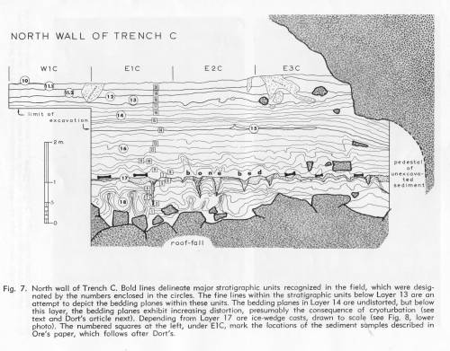
Labels:text | drawing | diagram OCR: NORTH WALL OF TRENCH C WIC EIC E20 E3C 12 limit of 14 excavation -2m Pedestal ted sediment roof-fall Fig. 7. North wall of Trench C. Bold lines delineate major stratigraphic units recognized in the field, which were desig- nated by the numbers enclosed in the circles. The fine lines within the stratigraphic units below Loyer 13 are an attempt to depict the bedding plones within these units. The bedding planes in Layer 14 are undistorted, but below this loyer, the bedding planes exhibit increasing distortion, presumably the consequence of cryaturbation (see text and Dort's article next). Depending from Loyer 17 are ice wedge casts, drawn to scole (see Fig. 8, lower" photo), The numbered squares at the left, under EIC, mark the locations of the sediment samples described in Ore's paper, which follows ofter Dort's